Himalayan VOICES
High Himalaya FORUM
Himalayan Heritage
Search
About Us
Objectives
Facilities & Extensions
Associated Structures
Organisation, Team & Partners
Explore the Himalayas
Factsheets
Geography
Culture
Ecology
Issues
Myths & Legends
Trivia
Maps
Administrative Maps
Ancient Maps
Maps of Tourist Interest
Physical Maps
Special Interest Maps
Himalaya Experiences
Travellers in History
Himalaya Aficionados
Online Library
Readings
Mountain Themes
Origin & Geography
Ecology & Environment
Society & Culture
Economy & Livelihoods
Others
Mountain Issues
Environmental Issues
Welfare & Infrastructure Issues
Social Issues, Gender & Indigenous Rights
Poverty & Resource Issues
Geopolitics
Others
E-Books
Origin & Geography
Ecology & Environment
Society & Culture
Economy & Livelihoods
Travelogues
Social Issues
Environmental Issues
Others
Conference reports
Himalaya Research
Culture Preservation
Ecology & Environment
Economy & Livelihoods
Technologies for Himalayas
Welfare & Infrastructure
Others
Himalaya Documentation
Natural Resources
E-herbaria
Cultivation Package
Ethnobotanic Database
Fauna
Cultural Resources
Tribes
Socio-economic Fabric
Language & Literature
Art, Crafts & Architecture
Resources & Tools
Organisations, Websites
Environment Conservation
Social Research & Welfare
Appropriate Technologies
Capacity Building
Poverty & Livelihoods
Culture Conservation
Disaster Management
Vulnerable Groups
Projects & Initiatives
Environment Conservation
Social Research & Welfare
Appropriate Technologies
Capacity Building
Poverty & Livelihoods
Culture Conservation
Disaster Management
Vulnerable Groups
Schemes & Programmes
Innovations
Appropriate Technologies
Infrastructure & Services
Land & Water Management
Livelihoods
Others
Reviews/ Feedback
Indicators & Guides
Natural Resource Management
Appropriate Technologies
Livelihoods
Welfare & Infrastructure
General
Policies & Legislations
International Policy Environment
Conventions
Declarations
Instruments
Country-Level Policies
India
Nepal
Other Himalayan Countries
Policy Research & Critiques
Media Gallery
Image Gallery
Landscape
Natural Heritage
Culture & People
Important Sites
Voices Gallery
Documentaries & Films
Culture & History
Exploring the Mountains
Natural Environment
People & Society
Road to Development
Music Gallery
Member
News & Events
Himalaya News
Himalaya Films
Upcoming Events
New publications
Home
>
Explore The Himalayas
>
Maps
>
Physical Maps
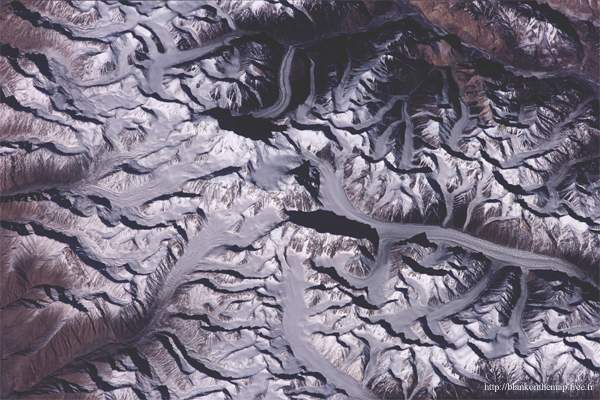
> Satellite Image of the Nanga Parbat area
Factsheets
Maps
Administrative Maps
Ancient Maps
Maps of Tourist Interest
Physical Maps
Special Interest Maps
Himalaya Experiences
Search
Select
Articles
Books
Select Category
View more Maps
All Himalaya
Indian Himalaya
Nepal Himalaya
Other Himalaya
PHYSICAL MAPS
Title:
Satellite Image of the Nanga Parbat area
Source:
Blank on the map
Description:
The Nanga Parbat range is an unreal rise of the earth's crust overhanging the Indus valley at a height of 8125m
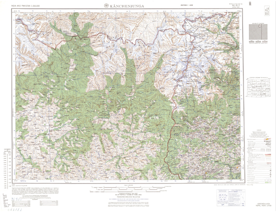
Title:
Topographical Map showing Kanchenjunga
Source:
Blank on the map
Title:
Satellite Image of the Saser Kangri Mountains
Source:
Blank on the map
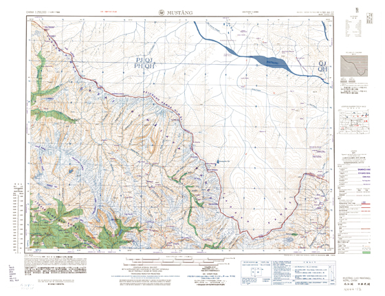
Title:
Topographical Map of Mustang district, Nepal
Source:
Blank on the map
back